Kerr County's Risk of Flash Flooding Increases Monday Afternoon, Know Your Plan
A Flood Advisory covers Kerr County until 4 p.m. Monday, with up to 2 more inches of rain on top of a soaked weekend. Here's how to be ready.
 ⛶ View the full radar
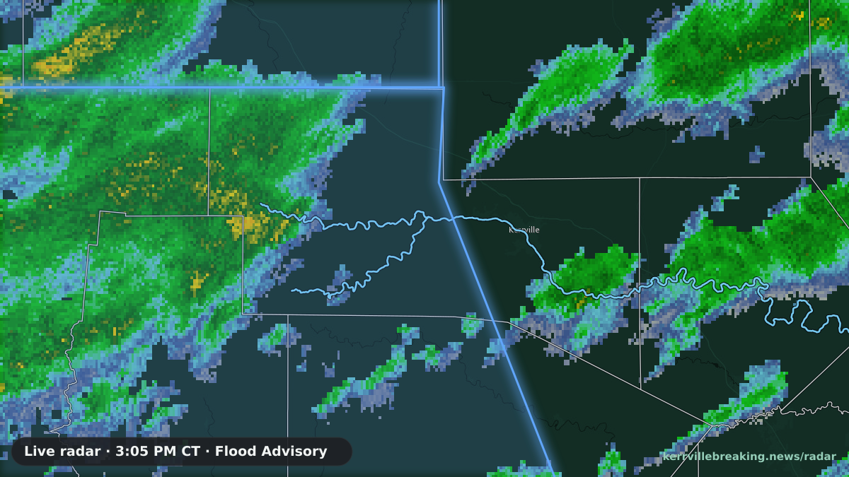
The live radar over Kerr County with the active National Weather Service advisories, redrawn every five minutes.
KERRVILLE — Kerr County is under a Flood Advisory until 4 p.m. Monday as a solid band of rain and embedded thunderstorms moves across the Hill Country — on ground that's already soaked from the weekend.
The National Weather Service in Austin/San Antonio issued the advisory at 8:17 a.m. for Kerr County and seven neighboring counties: Bandera, Edwards, Kinney, Medina, Real, Uvalde and Val Verde.
As of 8:15 a.m., radar showed 1 to 2 inches of rain had already fallen Monday morning. Up to 2 more inches are expected through the afternoon.
That rain is landing on top of Sunday's storms. On Sunday, NWS issued a Flash Flood Warning for northwestern Kerr County after 3 to 5 inches fell across the warned area. With the ground already saturated, more of Monday's rain can run straight off into creeks, streams and low-water crossings.
What to expect
According to the advisory, the rain is expected to cause:
- Rises in small streams and normally dry creeks
- Dangerous flows over low-water crossings
- Minor flooding in low-lying and poor drainage areas
- Overflowing poor drainage areas
Hunt is among the communities NWS expects to see flooding. The list also includes Vanderpool, Leakey, Tarpley, Medina, Camp Wood, Barksdale, Rocksprings, Uvalde and Del Rio.
What's underneath
Kerr County sits on karst: limestone shot through with caves, voids and fractures. KBN's Floodgate investigation has mapped 723 water-well driller logs across the county where drillers hit caves, voids and lost circulation.
The Upper Guadalupe River Authority has said as much itself. In its 2017 "Be Flood Aware" video, played to the Texas House committee investigating the July 2025 floods on April 27, 2026, UGRA tells viewers that "water from the Edwards Trinity Plateau Aquifer pushes through fractures in the rock and begins to flow overland. These springs form the headwaters of the North Fork, South Fork and Johnson Creek."
By UGRA's own account, then, the rivers that flooded are fed by aquifer water pushing through fractured rock. The Floodgate investigation's working explanation is that when that underground system fills during heavy rain, the pressure behind it adds water from below, on top of what falls from the sky. Its Checkmate analysis found that in 2026, about 15% more rain on saturated ground produced only about 60% of the 2025 peak.
After a weekend that dropped 3 to 5 inches on parts of northwestern Kerr County, that underground system is already taking on water. That's why your plan matters now, not when the water reaches your door.
Know your plan
Don't wait for the water to decide for you. The National Weather Service recommends:
- Know your risk. Find out whether your home is in a floodplain, where water collects on the roads you use, and your fastest route to higher ground.
- Pick a contact and a meeting spot. Choose someone everyone in the family checks in with and a safe place to meet if you get separated.
- Have a kit ready. Food, water and medicine for at least three days, plus flashlights, batteries, blankets, a first aid kit, rubber boots and gloves, and a NOAA Weather Radio or other battery-powered radio.
- Charge your phone and portable radios now, and have spare batteries on hand.
- Pack in advance for your family and pets in case you have to leave.
- Leave early. If flooding is likely where you are, go before you're ordered to. Line up a place to stay and take your pets with you.
Turn around, don't drown
The water doesn't have to look deep to be deadly. According to NWS, just 6 inches of fast-moving water can knock an adult off their feet. A foot of rushing water can carry away most cars, and 2 feet can carry away SUVs and trucks.
More than half of all flood-related drownings happen when someone drives into flood water. Never drive around barricades, and never drive or walk into a flooded road.
KBN will update this story as conditions change.
Sources: Upper Guadalupe River Authority, "Be Flood Aware" (2017), as played to the Texas House General Investigating Committee, April 27, 2026 (House video 22678, at 0:34:39) · Floodgate Report — Cavities · Floodgate Report — Checkmate · NWS — Before a Flood · NWS — Turn Around Don't Drown · NWS Flood Safety