KBN Flood Danger Assessment: Extreme Risk of Catastrophic Flash Flooding
Kerr County is under a Flood Watch through Friday evening. Kerrville appears in both National Weather Service excessive-rainfall outlooks, and the conditions are worse than before the first two disasters.

KERRVILLE, Texas — Kerrville Breaking News has been extensively researching the factors leading up to the first two catastrophic flooding events. The factors are shown in this assessment with the determination.
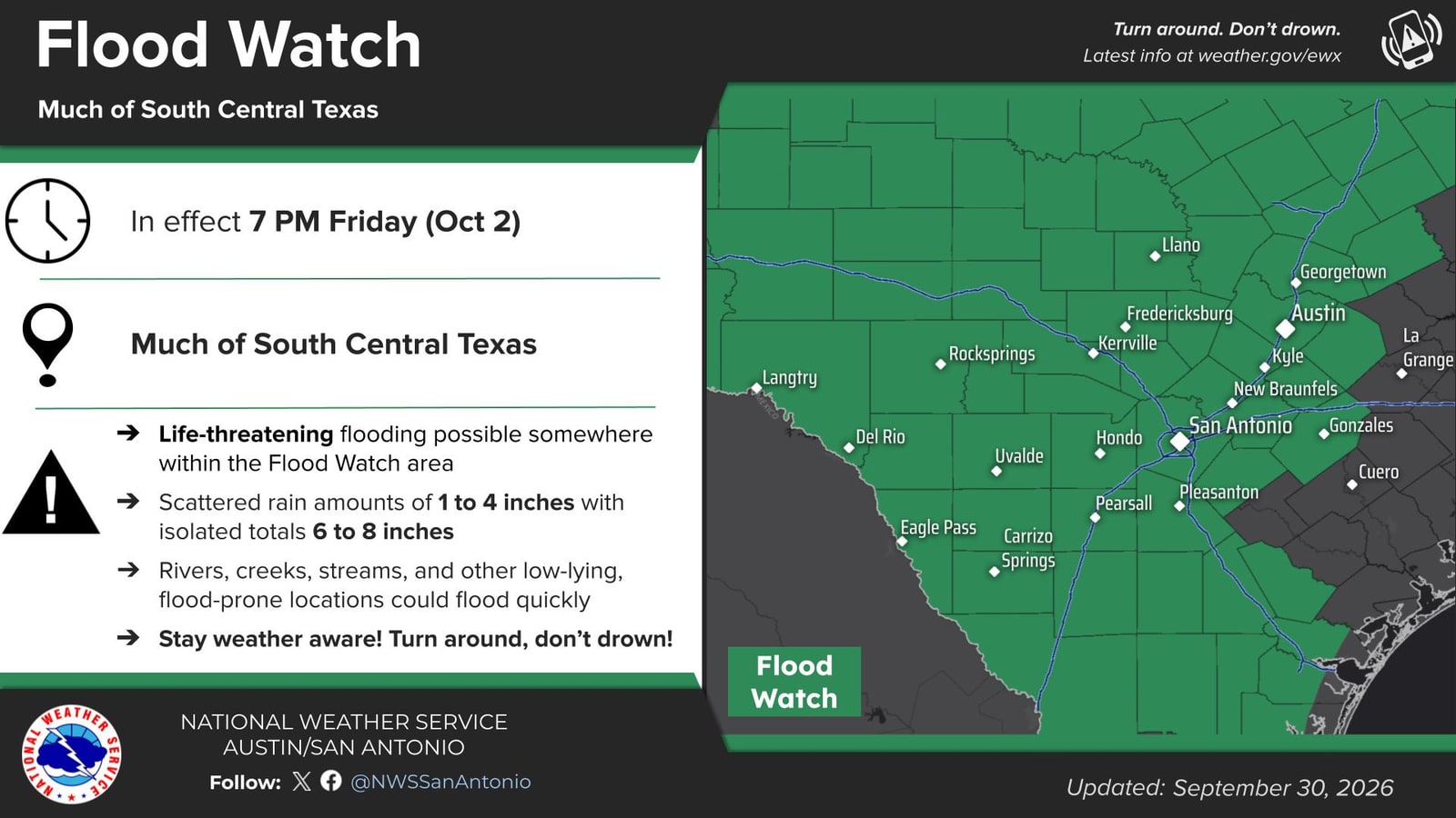
Kerr County is under a Flood Watch through 7 p.m. Friday, October 2. The National Weather Service issued it at 1:29 p.m. Wednesday. The state has already moved swiftwater rescue teams into position ahead of it.
Kerrville appears in both of the Weather Prediction Center's excessive-rainfall outlooks, and the "stated" larger risk area arrives Thursday. But set that against the Weather Service's own timing, because the two do not say the same thing.
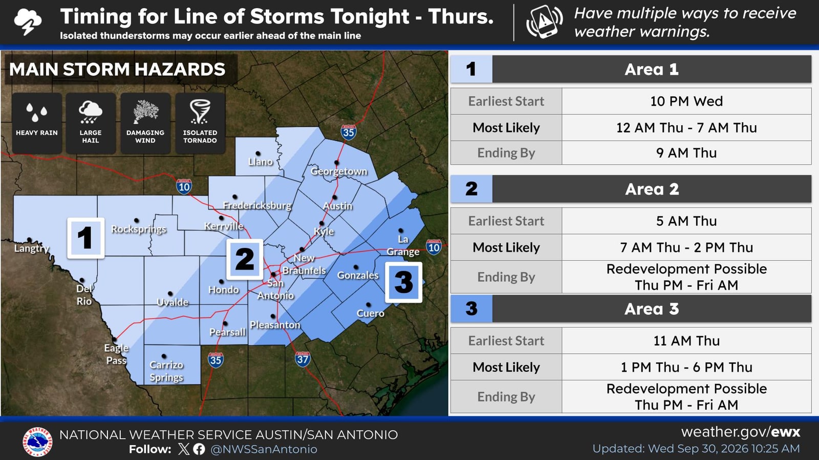
The round aimed squarely at us is tonight's. Ten p.m. to 7 a.m., over the Edwards Plateau and the western Hill Country — that is where Kerr County sits — and forecaster confidence in it is rated good. Thursday morning, 7 a.m. to 2 p.m., also covers us, also good confidence. The Thursday-night redevelopment is rated low confidence, and the area named for it is the central and eastern Hill Country, east of here.
But, look where Kerr County is in both days' maps. Kerr County sits in the red and yellow.
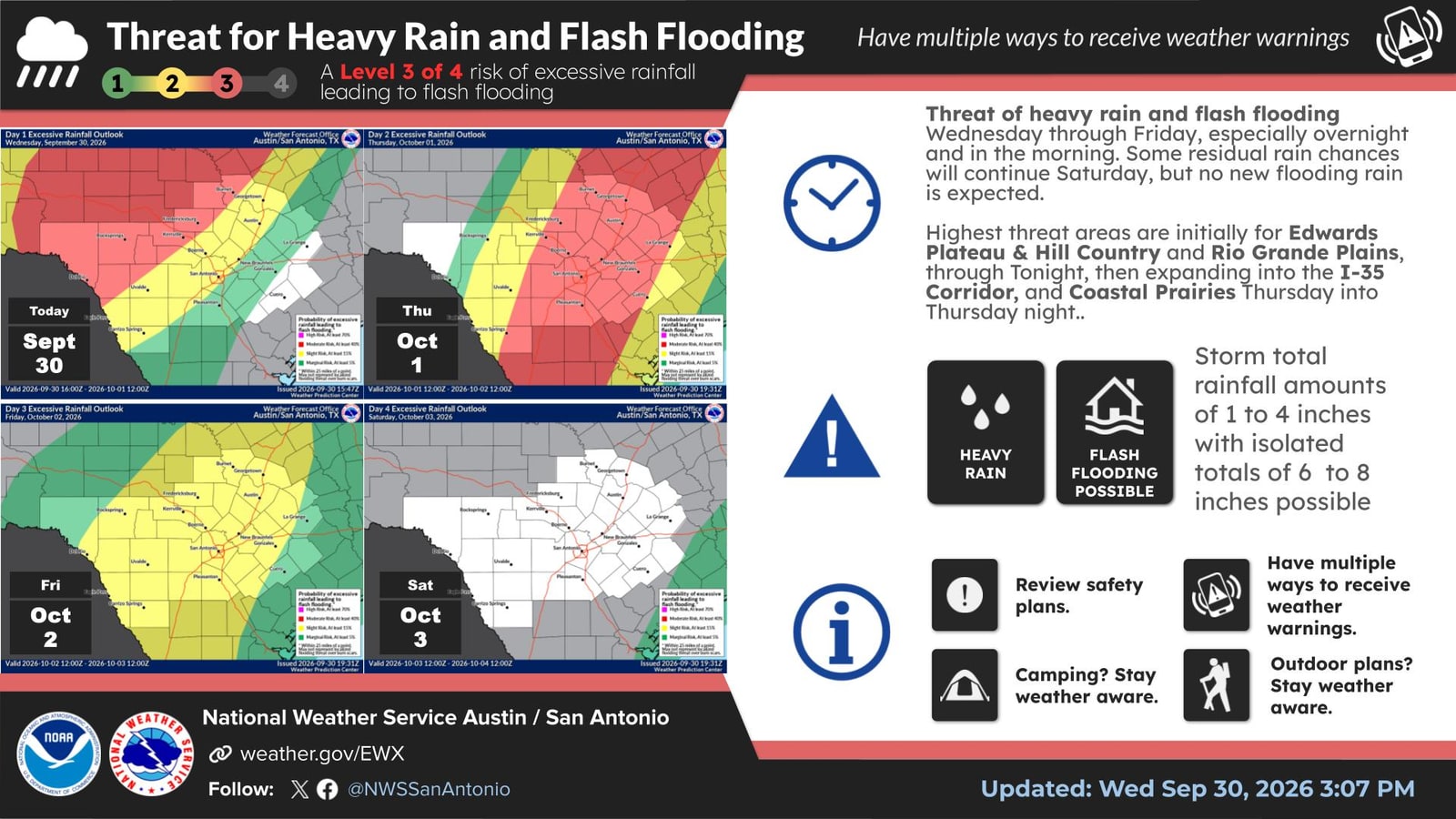
So the honest ordering is the opposite of the intuitive one. Tonight is the better-supported threat to this county. Thursday night is the uncertain one — and uncertainty runs both ways: it may not develop at all, or it may develop further west than advertised. Neither night gets written off.
Nobody should go to bed tonight thinking the dangerous part is tomorrow.
It does not take extraordinary rain here. It takes rain on a surface that is already loaded. July 4, 2025 is the example. A basin average of 5.99 inches fell above the Kerrville gauge — inside the range being forecast for tonight through Friday — and the Guadalupe reached 37.51 feet, the highest stage in the modern record. Six inches did that.
The flow figure that goes with it, 298,000 cfs, is an estimate: the gauge failed at the crest, and USGS published the peak as an estimated value in a record it has since approved. That distinction matters throughout this assessment. The largest flood anyone here has lived through was never actually measured.
The two storms either side of it, same basin, same gauge, same radar product, are what show why:
| Storm | Basin average | Wettest cell | Peak at the gauge |
|---|---|---|---|
| July 22–23, 2024 — drought-dry ground | 3.46 in | 7.38 in | 14,000 cfs |
| July 15–16, 2026 — wet ground | 6.42 in | 13.84 in | 180,000 cfs (provisional) |
| July 3–4, 2025 | 5.99 in | 10.72 in | 298,000 cfs (estimated) |
July 2025 had less basin-average rain than July 2026, and a smaller wettest cell — and it produced two-thirds again as much water. Against 2024 it had less than twice the rain and produced more than twenty times the flow. Whatever separates those three nights, it is not how much rain fell.
The difference is not in the sky. It is in what the ground was already holding when the rain arrived. Roughly six inches fell over this basin in both 2025 and 2026; 3.46 inches fell in 2024. The river answered with 9 feet, then 30, then 37. The rain totals sit within a factor of two of each other. The responses do not.
The forecast for tonight through Friday is 1 to 4 inches, with isolated amounts to 8. This basin is not dry. It is also not yet loaded the way it was on the eve of July 16, 2026 — and the first round of rain is what would load it.
Most of what falls will be ordinary rain. The danger is not the average, and it is not only the isolated cell. It is the isolated cell landing where the surface is already loaded — on either night.
1 · The official forecast
A slow-moving Pacific cold front, organizing over West Texas, pushing east.
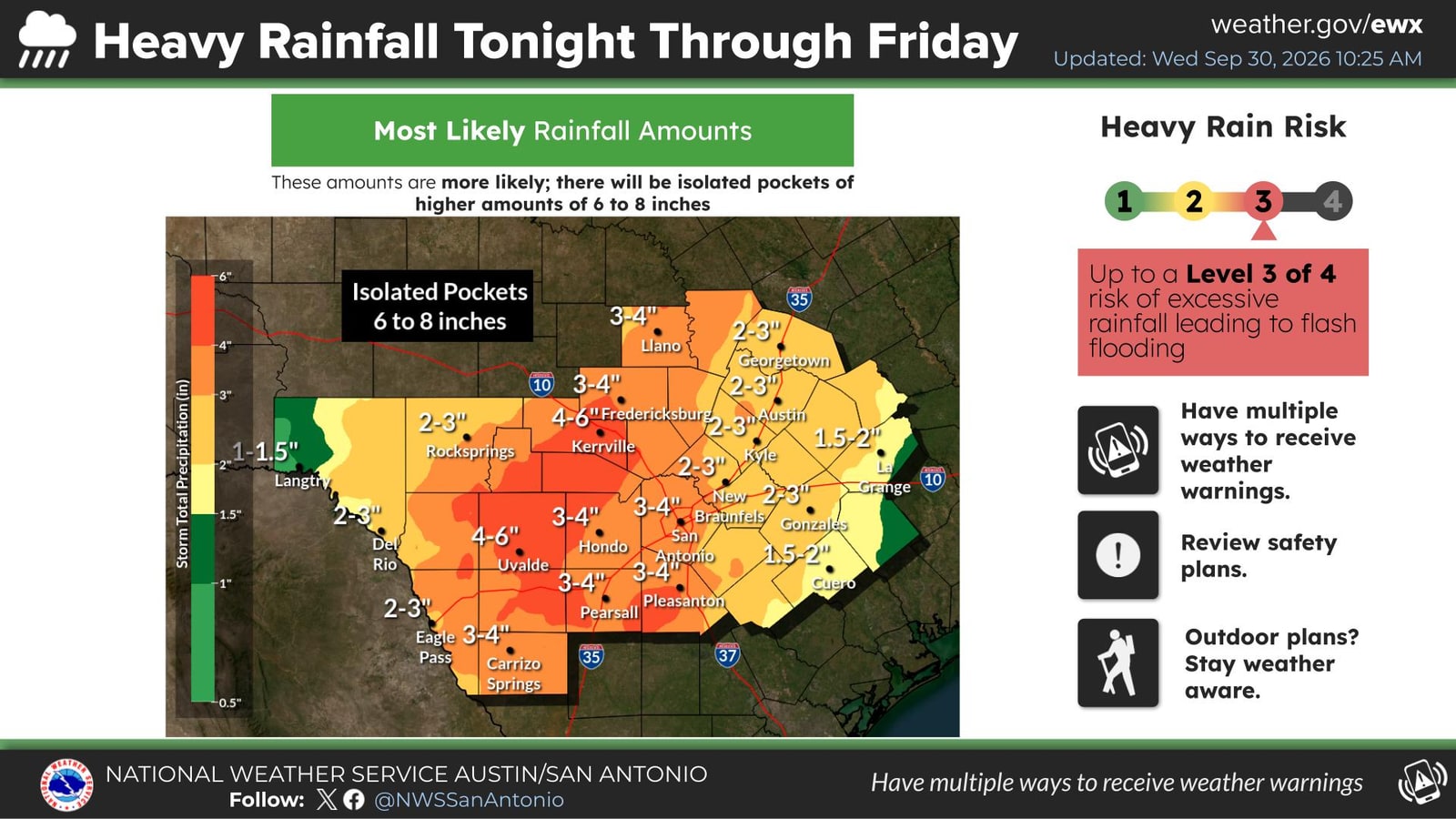
A Flood Watch is in effect for Kerr County and 27 other Central and South Texas counties, issued 1:29 p.m. Wednesday and in effect through 7 p.m. Friday, October 2. The Weather Service puts rainfall at 1 to 4 inches from tonight through Friday, with isolated amounts up to 8 inches, and states plainly: "There is a potential for life threatening flooding somewhere in the watch area." It names low-water crossings, creeks rising out of their banks, and flooding in poor-drainage areas. Kerrville is listed among the locations that may flood.
| Window | Area | Confidence |
|---|---|---|
| Tonight, 10 p.m. – 7 a.m. | Edwards Plateau, western Hill Country | Good |
| Thursday, 7 a.m. – 2 p.m. | Hill Country into the I-35 corridor | Good |
| Thursday 8 p.m. – Friday 10 a.m. | Possible redevelopment, central/eastern Hill Country | Unknown |
Regional totals of 1 to 4 inches. Isolated pockets in the modeling reaching 6 to 8 inches, at rates of 2 to 4 inches per hour where they set up.
Those two numbers do not sit together, and the mismatch is the whole thing. At 2 to 4 inches an hour, the entire regional total can fall on one creek inside an hour. A regional total is an average spread over thousands of square miles and three days; it is not a ceiling on what any one place receives, and nothing in it is binding on the basin above your crossing. A flood is made by what lands on one catchment in ninety minutes.
The first number is for planning your week. The second is the one that moves a river. Where they disagree, the rate wins.
Excessive-rainfall risk is a four-step scale, each step a probability of excessive rain leading to flash flooding within 25 miles of a point: marginal (≥5%), slight (≥15%), moderate (≥40%), high (≥70%).
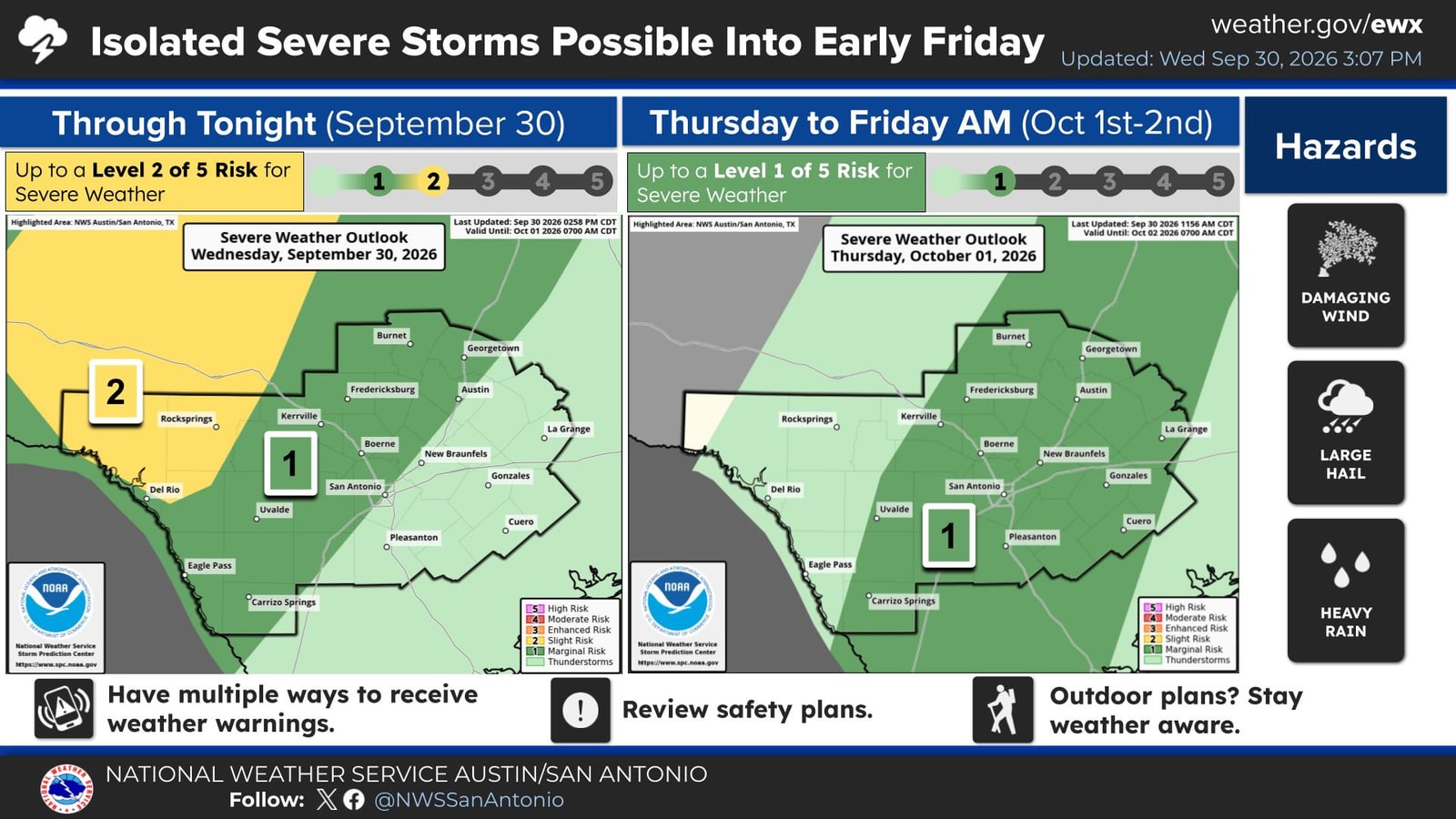
Kerrville: slight-to-moderate tonight. Moderate Thursday into Friday. Those are the outlook categories, which measure the chance of excessive rain somewhere within 25 miles of a point. They are not a ranking of which night is more dangerous here — the timing table above is, and it puts the best-supported round over our part of the Hill Country tonight.
Minor to moderate flooding is possible on the upper Guadalupe: the South Fork and North Fork above Hunt, and the main stem on through Ingram, Kerrville, Center Point and Comfort toward Canyon Lake.
The creeks that feed it are what decide a crossing — Johnson, Goat, Town, Quinlan, Third, Camp Meeting, Turtle and Upper Turtle, Bear, Indian, Kelly, Cypress and Verde. A creek can be the whole event. In July 2024 the rain fell on Johnson Creek, and the Hunt gauge upstream barely moved while the river at Kerrville came up 9 feet.
Severe storms are a secondary threat — level 2 of 5 tonight west of us over Edwards, Val Verde and northern Kinney; level 1 across the Hill Country both days, with a low but non-zero tornado risk tonight.
1b · What has already been moved into position
Texas A&M Task Force posted Wednesday that its responders are staged and positioned across Texas ahead of the threat, at the request of Governor Greg Abbott and under the direction of the Texas Division of Emergency Management. By its own count:
- More than 150 responders from over 20 agencies
- 13 swiftwater / flood rescue teams
- 3 helicopter search-and-rescue teams
- 31 rescue boats — 27 inflatable, 4 floodwater
- 2 high-profile vehicle packages, with further resources standing by
Water squads completed "just in time" training with the Texas Military Department on Wednesday. The Task Force's own words: "We are prepared. We are positioned. We are ready to respond."
We have not independently confirmed the staging locations, and as of Wednesday evening there is no release on the TEEX newsroom — the figures above are the Task Force's own, from its public post.
Read it as a measure of how seriously this is being taken. Rescue assets are moved before a storm when the people who move them expect to need them. That is the useful signal in it, and it is the reason to treat both nights as live.
It is not a reason to feel covered. Pre-positioned teams shorten the time from call to rescue. They do not shorten the time between dry pavement and a car floating, which in this county has been measured in minutes. Staged rescuers are the answer to a flood that has already caught someone. Not driving into water is one answer to the flood itself.
Locally, the city has staged too. Kerrville Police and the Kerrville Fire Department are on standby for calls and changing road conditions, and City Public Works crews have staged sandbags and barricades at locations prone to street flooding, with on-call teams ready to deploy if conditions worsen. Police ask residents to allow extra time, use caution, and stay home if they can.
Where road closures will appear: the Kerrville Police Department's page. The City of Kerrville posts city service changes and weather updates. The department also points residents to the National Weather Service Austin/San Antonio, trusted sources, and local news.
The police department states the threshold in the plainest available terms: six inches of moving water can knock a person down, and one foot can sweep a vehicle away. Never drive through water over a road.
2 · Antecedent conditions — our own reading
This is where our assessment departs from the regional framing.
The Weather Service called this rainfall beneficial five times in Wednesday's briefing. Across South Central Texas, fair. For this basin, the gauge disagrees.
One gauge, one measure: mean daily discharge over the fourteen days before each date, Guadalupe River at Hunt (USGS 08165500).
| Fourteen days before | Mean daily discharge |
|---|---|
| July 4, 2025 — the flood | 5.4 cfs |
| July 16, 2026 — the flood | 24.7 cfs |
| Today | 28.6 cfs |
Normal for this fortnight is 21.2 cfs, the median of every daily value from September 17–30 across 2015–2025. Today runs about a third above that.
That is more than five times the trickle the basin was running before July 4, 2025, and above the 16 to 17 cfs it held through most of the fortnight before July 16, 2026.
But baseflow is not saturation, and the 2026 comparison needs care. Look at what the Hunt gauge did in the three days before that flood: 17 cfs on July 12, then 21, then 75, then 67. Rain was falling on that basin right up to the event. The ground was taking water, and it was full when the storm arrived.
Today's record is flat — 27 to 32 cfs for a fortnight, no spike, no recent rain to speak of. So the basin is not dry, and it is not primed either. It sits between the two.
Carry that distinction into tonight, because it cuts both ways. The surface is not loaded the way it was on July 15, 2026. But tonight's rain is precisely what would load it — the first round is what prepares the ground for the second. That is the mechanism by which a two-night event becomes more dangerous on its second night, and it is the one way in which tomorrow genuinely could be worse than tonight.
Baseflow is not a soil-moisture probe. It is, however, the most direct public measure of how much water this ground is already holding and releasing — and by that measure the basin is not thirsty. Wet ground absorbs less of what lands on it.
Assessment: antecedent conditions are unfavorable. "Beneficial" is a regional characterization and should not be read locally as "the ground will soak this up."
2b · How this setup compares to the two floods
Three ambient measures, against the same measures during the July 4, 2025 and July 16, 2026 events.
Two of our measures compare like for like — the same gauge and the same well, on the same definition, for all three dates. Those are the ones we chart:
This is what those two nights looked like at the Kerrville gauge below Nimitz Lake Dam — the shape of the rise, and where the record breaks.
And this is the low-end case, the one that matters for judging tonight: July 22–23, 2024, when 3.46 inches over the basin — inside the range forecast for tonight — lifted the river 9 feet to 14,000 cfs on drought-dry ground.
Pressure is lower now than during either flood — and this reads live, so it is current whenever you are looking at it, not frozen at the hour we wrote this.
Every reading has been sitting below the minimum recorded during either flood. Kerrville Municipal Airport is not reporting, so the number above comes from the nearest station that is, and it says which one.
The wind is in the same quadrant. Resultant flow ran 149° (SSE) through the 2025 event and 119° (ESE) through 2026. At 4:50 p.m. it is 160° at New Braunfels, 140° at San Antonio and Del Rio, and 170° at Horseshoe Bay. All are onshore Gulf transport off the southeast quadrant — the direction that carries moisture into the Hill Country — though today's flow runs more southerly than either flood.
The aquifer is between the two. Monitoring Well #11, the Lower Trinity well 2.7 miles south of the Kerrville ASR field, stood at 309.5 feet below land surface entering the 2025 flood and 330.3 feet entering 2026. It reads 317.3 feet now — about 8 feet lower than 2025, 13 feet higher than 2026.
That well is not incidental to the Kerrville water system. Its head tracks the city's ASR injection well with a lag of about one day — consistent with fast pressure transmission through the confined Lower Trinity rather than water moving the 2.7 miles. The correlation is real but modest, and it is a pressure signal, not a flood forecast.
What this does and does not mean. Low pressure and onshore southeasterly flow are the ordinary ingredients of almost any Hill Country rain event. Finding them again is not a prediction, and we are not offering it as one. What it establishes is narrower: on the ambient measures we can check, today resembles the run-up to July 4, 2025 and July 16, 2026 — the two days when there was loss of life in this county. That is a reason to take the forecast seriously, not evidence of what the forecast will do.
A note on sourcing: the Kerrville airport station is not returning current observations, so the live pressure and wind readings above come from Fredericksburg, New Braunfels, San Antonio and Del Rio.
2c · Where do the cells form? Everywhere.
If the danger is an isolated cell landing on loaded ground, the obvious question is whether there is a part of the county that tends to get them — and, by extension, a part that does not.
We went looking. The Floodgate Report scanned 1,571 days of archived radar from the two NEXRAD sites that cover this county, June 2022 through September 2026, and logged every storm birth: a new echo appearing where there had been none. Counting only the convective ones, and counting days rather than storms so a single long-lived cell cannot manufacture a pattern:
The answer is that there is no safe corner. Tested formally, not one cell inside Kerr County comes back as a significant hotspot. The places that do light up in the wider region sit close to the radars themselves, which is the signature of fixed-pixel clutter rather than weather.
That is a null result, and we are publishing it as one. It is also the most practical thing on this page tonight. Storms here are born over the whole county, and no part of Kerr County has earned the right to be treated as the low-risk part. If you were hoping the cell would form somewhere else, four years of radar says there is no somewhere else.
3 · Why “the ground is too dry to absorb it” isn’t the thing to watch
You will hear, tonight or tomorrow, that hard dry ground sheds rain and makes flooding worse. It is a common explanation and it circulated widely after July 4, 2025. It is worth understanding why it doesn’t hold, because it points people at the wrong risk.
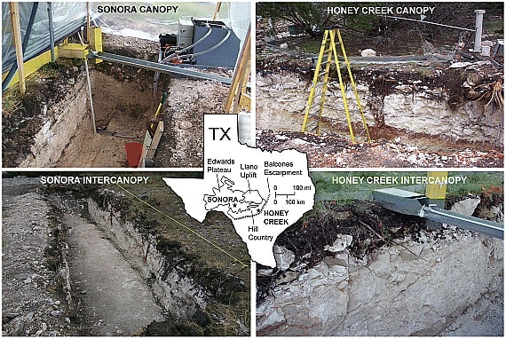
The soil behaves the opposite way here. Kerr County was in D3–D4 drought in July 2025. But dry clay over karst absorbs rain rather than repelling it. The peer-reviewed work on this is Wilcox, Taucer, Munster, Owens, Mohanty, Sorenson and Bazan, “Subsurface stormflow is important in semiarid karst shrublands,” Geophysical Research Letters, 2008. They ran large sprinkler experiments on instrumented Edwards Plateau karst hillslopes at flood intensities — up to 3.1 inches per hour at their Comal County site and 7.5 inches per hour in Sutton County — and measured no overland flow at all on juniper-canopy slopes, the dominant Hill Country cover. Forty to eighty percent of the applied water left through the subsurface instead, along fractures, root channels and conduits. Open ground between the trees did shed water, 10 to 50 percent of it. Neither site is in Kerr County; they sit east and west of it on the same plateau karst, which is the honest limit of what the experiment proves here.
And the volumes are beyond what any soil condition explains. The flood basin ran a runoff coefficient of 2.5 to 4.0 — the South Fork alone 4.0 to 6.7. A coefficient above 1.0 means more water left the basin than fell on it as rain. That is impossible from rainfall, whatever the ground is doing. Two control basins under the same storm ran 0.56 and 0.22.
Floodgate Report I set out that finding in full; the question of where the rest of the water came from remains open.
For tonight the practical point is simpler: don’t use soil condition to judge your risk either way. It won’t tell you whether a crossing is safe. Rainfall rate and how fast the creek is rising will.
3b · The creeks, by name
The watch covers 28 counties. Here is what it means for the water that actually runs past Kerr County doorsteps — the Guadalupe from the forks at Hunt through Ingram, Kerrville, Center Point and Comfort and down to Canyon Lake, and the creeks that feed it.
What is being measured tonight — every real-time gauge in this basin, read at 7 p.m.:
| Gauge | Reading now |
|---|---|
| South Fork Guadalupe at Lynx Haven Crossing, nr Hunt | 4.48 ft (stage only — no flow reported) |
| North Fork Guadalupe nr Hunt | 16.7 cfs · 1.56 ft |
| Johnson Creek nr Ingram | 15.5 cfs |
| Guadalupe at Hunt | 29.0 cfs · 7.73 ft |
| Guadalupe above Bear Creek at Kerrville | 48.8 cfs · 2.88 ft |
| Guadalupe at Kerrville, below the Nimitz dam | 33.3 cfs · 1.11 ft |
| Guadalupe nr Center Point | 61.8 cfs · 4.22 ft |
| Guadalupe at Comfort | 73.6 cfs · 3.25 ft |
| Guadalupe nr Spring Branch | 75.8 cfs |
| Guadalupe above Canyon Lake | 189 cfs |
And here is what nothing is watching. These creeks have no stream gauge of their own — not a failed one, not a limited one. None:
Town Creek · Quinlan Creek · Third Creek · Camp Meeting Creek · Goat Creek · Turtle Creek · Upper Turtle Creek · Indian Creek · Kelly Creek · Verde Creek
Four of those — Town, Quinlan, Third and Camp Meeting — run through Kerrville itself. If one of them comes up tonight, no instrument will report it. Somebody will have to see it.
Bear Creek is a special case. There is a gauge named for it — Guadalupe River above Bear Creek — but the name says what it does. It sits upstream of the confluence, so whatever Bear Creek itself is carrying never reaches that reading.
Camp Meeting Creek enters the Guadalupe below both Kerrville gauges. A rise coming down it is invisible at Kerrville; Center Point is the first gauge that could see it at all.
A name that trips people up: the gauged Cypress Creek is at Saur Farm near Comfort. The Cypress Creek that comes down to the South Fork at Camp Mystic is a different creek, and it has no gauge.
The two numbers that matter most tonight
Two of these gauges cannot measure a flood, and both are already well up their range before a drop has fallen.
| Gauge | Reading now | Highest it can report | Range left |
|---|---|---|---|
| Guadalupe above Bear Creek at Kerrville | 2.88 ft | 4.3 ft | 17 inches |
| Guadalupe nr Center Point | 4.22 ft | 6.3 ft | 25 inches |
These are not estimates. They are the published limits of each gauge's rating. Above Bear Creek tops out at 399 cfs, Center Point at 600 cfs — in a river that ran to six figures in 2025.
Both behaved exactly as those limits predict on July 4. Center Point reported 539 cfs while standing in 39.61 feet of water. It did not break. It reported the largest number it is able to report, and the river went on rising past it.
So when a crossing near Center Point or near Bear Creek is in question tonight, the gauge is not the thing to check. It will read near its maximum and stay there, whether the river is a foot over the limit or thirty.
4 · What to know about warning and gauges here
These are standing conditions rather than anything about this storm, and they shape how you should plan.
Three to six hours is the forecaster’s margin — not yours. That figure is the Weather Service’s own, and it describes how far ahead the heavy cells can be located in a setup like this one. It is the time available to the people issuing warnings, not the time available to a person standing beside a creek. What reaches you is shorter, and can be far shorter — the Camp Mystic sequence below ran eight minutes from dry grass to a rooftop. Do not plan on having hours. A county-wide Flood Early Warning System is in the planning phase and not yet operating, so warning tonight will come from the Weather Service, local dispatch and your own eyes — not from an automated alert tied to the creeks. Plan on checking conditions yourself before you travel.
Gauges can fail at the peak. Of eight gauges on the Guadalupe corridor, four failed to record the July 4, 2025 crest, in three separate ways: rating ceilings far below flood scale, ratings exceeded by the flood, and outright sensor failure. Center Point reported 539 cfs while standing in roughly 40 feet of water. Hunt was rated to 350,000 cfs — well above the peak — and simply went dark. The Kerrville gauge failed again on July 16, 2026.
So a low gauge reading during heavy rain is not reassurance. If it is raining hard upstream, treat the crossing as dangerous regardless of what a gauge says.
And the official peaks are themselves estimates. At Hunt, USGS published 315,000 cfs for July 4, 2025. That figure comes off a rating curve whose top end is drawn to a single indirect measurement — 314,000 cfs at 37.52 feet — which USGS rated Poor and published with no width, no area and no velocity. The largest discharge USGS has ever directly measured at that gauge since 1941 is 47,000 cfs, and the widest channel it has ever measured there is 125 feet. The flood section, surveyed from 1-meter LiDAR and 25 high-water marks, is 2,251 feet wide.
Our own reconstruction of that surveyed cross-section does not land on a single number either. Run through Manning's equation it gives about 194,000 cfs. Run through the velocity the county engineer cited, it gives 356,000 to 508,000 cfs, centered near 446,000. We publish both, because both are estimates from the same measured geometry and they disagree by more than a factor of two.
Which is right is not the point here. The point is that the largest flood in this county's modern history was never measured — not by the instrument, and not by us. The full working is in Mockingbird.
What the Hunt gauge has actually measured, against what the modeling says it should:
It can happen faster than people plan for. At Camp Mystic on July 4, a photograph timed 3:23 a.m. shows campers walking on dry grass in heavy rain. A second photograph, timed 3:26, shows the water past their ankles and the canoes floating.
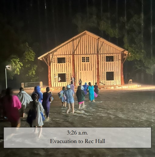
At 3:31, a 911 caller at the 2,000 block of Highway 39 — four miles downstream — was on her roof, telling dispatch the water was still rising. She called back at 3:39 to say it was rising still, asking if they can send a helicopter.
Four miles upstream at Camp Mystic at around 3:40, counselors watched Dick Eastland guide Bubble Inn campers from the cabin into his Tahoe.
It was not everywhere at once. Less than four minutes after the 3:31 a.m. call, Hunt Volunteer Fire Department Chief, Lee Pool, received a dispatch tone out at 3:35 a.m. about the callers four miles downstream from Camp Mystic. He called dispatch and cleared the call, turned right out of his neighborhood onto Hwy 39, and says this about his experience.
"Normally, and we've lived here for 19 years, that low water crossing has water flowing across it when it's flooding. This particular night, it had no water running across it, which struck me very odd that we were getting calls for a flood. Where's the water?"
Chief Pool was just 5.5 miles downstream from callers at the 2,000 block of Hwy 39.
Three events at the same time:
Camp Mystic: 4:40 a.m. — Dick Eastland is loading campers into his Tahoe
- 4 miles - 2,000 block of Hwy 39: 3:39 a.m. — 911 callers were on their roof asking for a helicopter
- 5.5 miles - Cypress Estates Pkwy and Hwy 39: ~3:40 a.m. — "Where's the water?"

The flood was not consistent — catastrophic at one address and absent a few miles below it inside the same ten minutes. That is the thing to understand tonight: the river looking fine where you are standing is not information about the next bend, or about the next ten minutes where you are standing.
It did not come down the North Fork. The North Fork gauge above Hunt survived that night and recorded 58,600 cfs — a large flow, and nothing like what arrived downstream, much later than it should have.
For scale: over the 29 hours from 1 p.m. July 3 to 6 p.m. July 4, 2025, radar-gauge rainfall averaged 5.99 inches across the 487-square-mile basin above the Kerrville gauge, with a wettest cell of 10.72 inches. The event that happened at Camp Mystic was hours before daylight, less than five hours after any rain fell over the south fork. The July 15–16, 2026 window averaged 6.42 inches, wettest cell 13.84. An isolated six-to-eight-inch pocket in the wrong place is not a smaller number than either. The first flooding dispatch was issued at 10:52 p.m. By 1:30 a.m., deputies from all throughout the county were reporting 2-4 feet of water running over roadways.
Rain on that basin against the river's response, for all three July floods:
5 · Determination
EXTREME RISK OF CATASTROPHIC FLASH FLOOD BOTH NIGHTS, 9/30/26 THROUGH 10/01/2026 AND 10/01/2026 THROUGH 10/02/2026
The likeliest outcome for most of Kerr County is useful rain. But four factors stack against the average case here: the round the Weather Service has the most confidence in is the one aimed at our part of the Hill Country, and it is tonight's; the surface is already loaded, which is the condition that separates a 14,000 cfs response from a 298,000 cfs one; the warning margin belongs to forecasters, not to residents; and the instruments that would confirm a flood in progress have a documented record of failing at the moment they are needed.
Thursday night is not dismissed here — it is simply the less certain of the two, not the worse of them. A low-confidence forecast is not a low-risk forecast. It means the people drawing it do not yet know whether the cells will redevelop, or where. That is a reason to check again tomorrow evening, not a reason to relax tonight.
None of that is a prediction that this front will flood Kerr County. It is a statement about which way the uncertainty runs — and about where the danger concentrates if it does. Low-water crossings are life-threatening in these conditions, and they are where the risk to an ordinary evening becomes real.
If your routine route takes you through a low-water crossing, plan a different one for tonight and tomorrow night. Turn around, don't drown.
What would change this assessment
- A Flood Warning replacing the Watch for any part of the county — act, do not reassess
- Tonight passing quietly — does not downgrade Thursday night, and the reverse is equally true
- The second round failing to redevelop, or redeveloping east of I-35 — downgrade
- Heavy cells setting up over the South Fork, North Fork or Johnson Creek headwaters — upgrade sharply
- Hunt or Kerrville gauges showing a rapid stage rise — treat as real and act; do not wait for confirmation
What to do if it floods
Nothing here is novel. It is the standard guidance, written for this county, on the night it applies.
If you are driving
Turn around. Don't drown. Never drive through water over a road, and never drive around a barricade.
- Six inches of moving water can knock a person off their feet. One foot can carry a vehicle away. Kerrville Police published both figures Wednesday.
- You cannot judge the depth from the driver's seat, and at night you cannot judge it at all. The road under the water may not still be there — the current scours the roadbed out from beneath the surface, so a crossing that looks like a puddle can be a hole.
- A barricade that looks unnecessary is a barricade doing its job. Public Works has pre-staged barricades at the crossings that flood. If you find one, the crossing is on a list because it has done this before.
- If your usual route takes you through a low-water crossing, pick a different route now, while it is dry and you can think about it calmly.
If water is rising where you are
- Go up, not out. Moving on foot through moving water is how people are swept away. If you can get to a higher floor or higher ground without entering the water, do that instead.
- Do not wait for the water to tell you it is serious. The Camp Mystic sequence ran eight minutes from dry grass to a rooftop.
- Take a phone and a light. Rooftops at night are where rescuers have had to look, and a light makes the difference between being found and being searched for.
- Move before dark if you have a choice. Both danger windows here are overnight, and everything is harder after sunset.
If you are calling 911
Give the dispatcher, in this order:
- Your address, including the highway number or the crossing name. The creeks here run close together and the addresses repeat.
- How many people are with you, and whether anyone is a child, elderly, or unable to move on their own.
- Whether you can still get out on foot without entering water — this is what decides whether you need a vehicle or a boat.
- Where you will be if the water keeps rising — upstairs, attic, roof. Say it before you need it.
Then stay reachable. Call back if it changes.
Do not trust a gauge to confirm it
This is the local part, and it is why the section exists.
- Two of the gauges on this corridor cannot measure a flood. Above Bear Creek tops out at 399 cfs, Center Point at 600. On July 4, 2025, Center Point reported 539 cfs while standing in 39.61 feet of water.
- Ten of the creeks named in this assessment have no gauge at all — Town, Quinlan, Third, Camp Meeting, Goat, Turtle, Upper Turtle, Indian, Kelly and Verde. Four run through Kerrville.
- So a low reading during heavy rain is not reassurance. If it is raining hard upstream of you, act on the rain, not on the number.
Where information will come from
- National Weather Service Austin/San Antonio — watches, warnings and the forecast.
- Kerrville Police Department — road closures.
- City of Kerrville — city services, and changes to operations or events.
- 911 — for an emergency, not for information.
A county-wide Flood Early Warning System is still in the planning phase. Tonight, the warning comes from the Weather Service, from local dispatch, and from your own eyes.
Afterwards
- Do not walk or drive through floodwater that is going down. It carries what it has picked up, and the road under it may be gone.
- Assume the water is contaminated. Wash anything it touched; do not let children play in it.
- Photograph the damage before you clean it up, including the high-water line on the wall.
- If tonight is hard to sit with, Hill Country MHDD's 24-hour line is 877-466-0660, and the national Suicide and Crisis Lifeline is 988.
If you are reading this and the water is already coming up: stop reading and move to higher ground.
If the forecast itself is hard to sit with
An assessment like this one is frightening to read, and it is meant to be taken seriously rather than to be lived with all night. In a county that has recovered people after two floods, a forecast is not an abstraction, and the anxiety it sets off is not an overreaction.
Hill Country MHDD Centers — the state-designated mental health authority for Kerr and eighteen surrounding counties — posted its own guidance Wednesday.
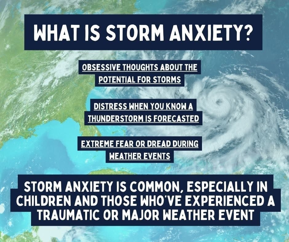
Their suggestions, in their words:
- Create a routine: Try to establish some sense of normalcy, even if it’s small.
- Make a weather plan: Having a plan in place for storms helps us regain a bit of control and a way to take action during bad weather if needed.
- Talk about your experience: Whether with a friend, family member, or in a support group.
- Practice self-care: Prioritize sleep, healthy meals, and movement can lower stress.
- Limit media exposure: While staying informed is important, constant news updates can increase anxiety.
- Connect with others: Reach out to loved ones and check in on each other. Social connection is a powerful tool in managing mental health during tough times.
Their 24-hour crisis line is 877-466-0660, listed by Texas Health and Human Services and answered around the clock; a Spanish-speaking counselor can be requested. The Kerr County center is at 955 Water St., Kerrville. The national Suicide and Crisis Lifeline is 988.
If tonight is frightening because of what you lived through in July 2025 or July 2026, that is not fragility. It is memory doing exactly what it does.
Forecast and outlook levels: National Weather Service Austin/San Antonio briefing and NOAA Weather Prediction Center Day 1 and Day 2 Excessive Rainfall Outlooks, issued 11:00 a.m. CDT September 30, 2026. Flood Watch text: National Weather Service Austin/San Antonio, issued 1:29 p.m. CDT September 30, 2026. City staging, road-closure and safety information: Kerrville Police Department, September 30, 2026. Pre-positioning figures: Texas A&M Task Force public post, September 30, 2026, as posted; not independently confirmed. Discharge figures: USGS gauge 08165500 daily values, retrieved 4:50 p.m. CDT. Pressure and wind: NWS station observations, 4:50 p.m. CDT. Runoff coefficients, rainfall totals, gauge-failure findings and the Camp Mystic timeline: Floodgate Report research, from USGS records, NOAA MRMS precipitation data, and City of Kerrville and Kerr County documents. Rainfall-simulation result: Wilcox, B.P., Taucer, P.I., Munster, C.L., Owens, M.K., Mohanty, B.P., Sorenson, J.R., and Bazan, R. (2008), “Subsurface stormflow is important in semiarid karst shrublands,” Geophysical Research Letters 35, L10402, doi:10.1029/2008GL033696.
Kerrville Breaking News issues this assessment independently. Where our reading differs from an official characterization, we say so and show the work behind our findings.