
The Faults Beneath Our Hills and the Catastrophic Consequences of Ignoring Reality
KERRVILLE, TX — It is a phrase woven into the local lexicon: "The Texas Hill Country." But a growing body of multi-station radar analysis, GIS mapping, and hydrogeological data suggests a far more accurate name for our landscape: The Fault Country.
For over a decade, Kerr County residents experienced the local fault corridor as a weather shield. The terrain routinely acted like a storm "repeller," splitting incoming rain fronts and deflecting convective cells around the basin. But in 2024, the atmospheric magnet flipped. What once repelled storms has officially transitioned into a catastrophic convective anchor—putting the county in danger of unprecedented flooding.
The Thermal Flip: From Shield to Convective Engine
An analysis of multi-year NEXRAD radar data from both New Braunfels (KEWX) and Laughlin AFB (KDFX) confirms that the Balcones Fault Zone (specifically Fault #12) now acts as a stationary magnet for severe weather.
This dramatic shift from storm repeller to storm anchor comes down to boundary-layer thermal dynamics:
- The Historical Heat Dome (The Repelling Phase): For years, severe groundwater drawdown, thin limestone soils, and dry surface conditions created localized thermal capping over the fault line. Incoming storm fronts hit this dry heat bubble and split or pushed downstream, leaving the area in a convective shadow.
- The Thermodynamic Flip (2024–2026): As atmospheric moisture patterns shifted and high Equivalent Potential Temperature () air surged into Central Texas, the thermal budget along the fault zone flipped. Soundings from recent flood events show extreme values between and (ERV 74/73°F, T82 73/72°F).
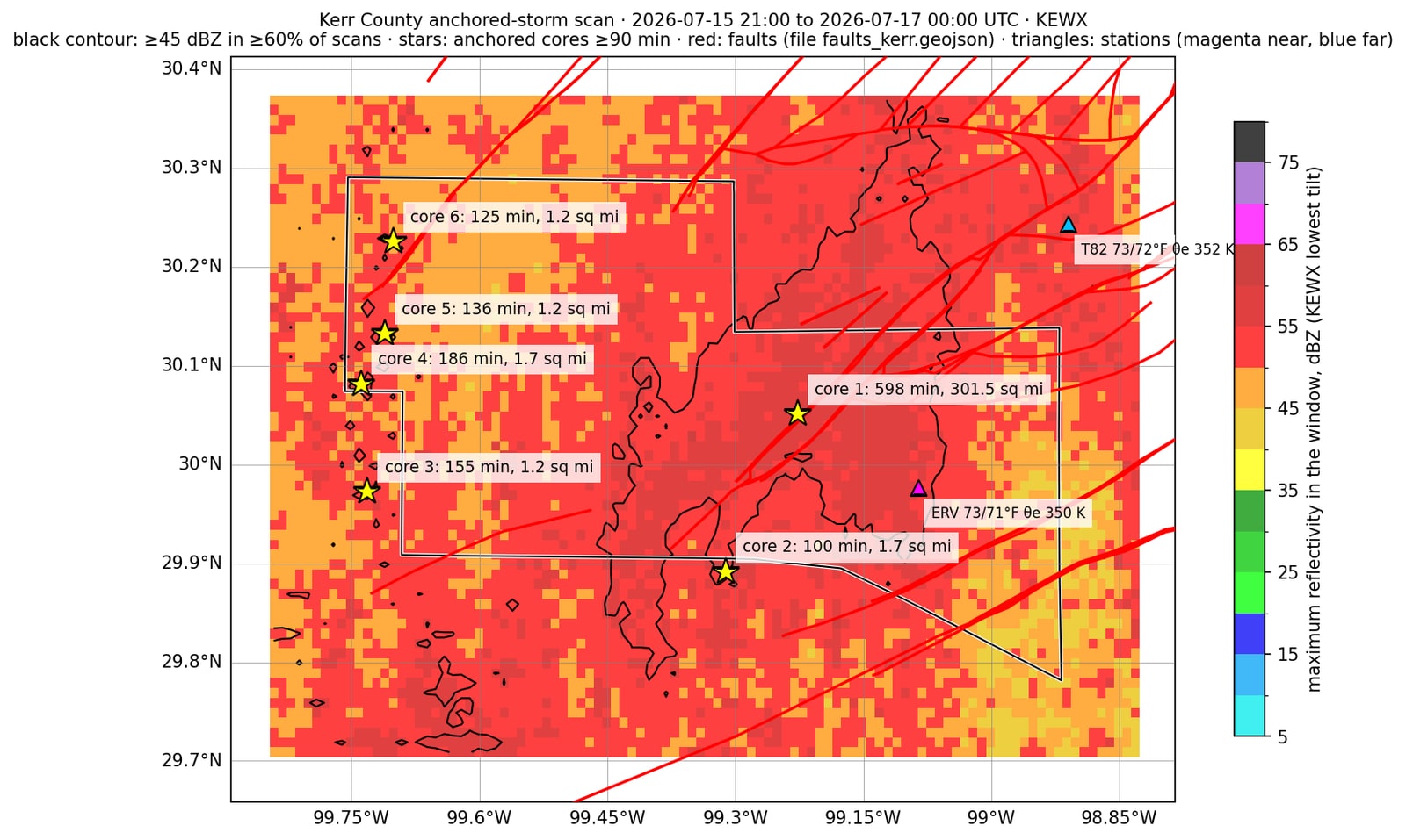
- The Orographic Ramp: Instead of capping storms, the elevation step along Fault #12 now acts as a mechanical wedge. When hyper-unstable Gulf moisture hits this ridge, it forces continuous updrafts, locking heavy reflectivity cores () directly overhead. During the July 15–16, 2026 event, a single core remained anchored over the central fault corridor for nearly 10 hours (598 to 613 minutes).
- Dual-Radar Verification: Opposing sweeps from KEWX (east) and KDFX (west) record identical stationary footprints, eliminating any possibility of radar beam blockage, ground clutter, or processing artifacts.
July 22, 2024 — Kerr County Anchored Storm Scan
During the July 22–23, 2024 storm event, the anchored convective cores aligned directly along Kerr County's structural fault corridors, unleashing an intense, stationary deluge over the Johnson Creek watershed. Core 7 alone remained locked over the upper basin for 300 minutes (5 hours), covering an 88.2-square-mile footprint with radar reflectivities continuously exceeding . Fueled by an extremely rich moisture mass (), this persistent atmospheric anchor dumped prolonged, heavy precipitation directly into the Johnson Creek drainage basin, driving rapid surface runoff into the exposed fault fractures and triggering severe flash flooding downstream along the Guadalupe River network.
The July 22–23, 2024 storm served as an early structural blueprint of Kerr County's transitioning weather regime, displaying a distinct multi-core alignment that mirrored the underlying geological faulting. Instead of a single, continuous rain mass, high-resolution radar analysis captured convective cores locking onto two separate linear fault trends, leaving lower totals in the un-faulted terrain between them. This event demonstrated how the fault corridor's boundary-layer thermal dynamics began actively steering atmospheric moisture, concentrating heavy precipitation along precise geologic fractures.
During the July 2024 deluge, MRMS gauge-corrected data captured two distinct precipitation hot spots locking directly onto the mapped structural fault traces:
The Upper Core (Johnson Creek / Mountain Home): A primary accumulation cell anchored just north of Mountain Home, peaking at 7.3 to 7.62 inches (wettest single spot 8.26 inches). This heavy reflectivity core sat directly over the northern structural fault trend.
The Southern Corridor: A secondary high-accumulation band stretched along the southern fault line near the county boundary, recording block totals from 5.4 to 6.5 inches.
The Fault-Guided Gap: The region immediately between these two fault-anchored cores received significantly less rainfall (3.3 to 4.2 inches), demonstrating how the atmospheric moisture engine specifically picked out and locked onto the linear geologic fractures rather than dropping water uniformly.
The official USGS hydrograph for the Guadalupe River at Kerrville (08166200, Nimitz Lake Outflow) during the July 22–23, 2024 event demonstrates the early stage of this hydro-mechanical activation pattern. Starting from a low baseline flow of just 11 cfs at 4:00 PM on July 22, the river remained largely dormant overnight before experiencing a sharp, multi-peaked discharge surge as the fault-anchored cores locked overhead.
The flow violently escalated to a primary peak of 14,000 cfs at a gage stage of 9.32 feet at 10:15 AM on July 23, followed immediately by a rapid secondary pulse exceeding 11,000 cfs. This distinct double-peaked signature directly reflects the dual-core alignment along the northern and southern fault trends, showing how discrete subterranean pressure waves and localized fault loading manifest as sharp, rapid-fire discharge pulses at the Nimitz Lake outlet.
A video shot and produced by local photographer and videographer Aaron Yates shows the level of flooding that the river rose to in the afternoon of July 23, 2024.

July 4, 2025 — Kerr County Anchored Storm Scan
During the July 3–4, 2025 flood event, NEXRAD radar scans (KEWX tilt) captured a terrifying demonstration of terrain-anchored convection as multiple storm cores locked directly onto the regional fault network. The initial anchor (Core 1) established itself over Bandera County from 10:36 PM to 12:41 AM, holding high reflectivities () for 125 minutes. Shortly after midnight, the system’s primary engine—Core 2—locked onto Kerr County directly over the fault corridor. Core 2 remained stationary for an extraordinary 616 minutes (over 10 hours) from 12:11 AM to 10:26 AM on July 4, blanketing a massive 220.4-square-mile footprint with heavy reflectivity up to .
While Core 2 hammered Kerr County, secondary anchored cores continuously re-ignited along adjacent fault traces, including Core 3 in Bandera County (12:58 AM to 3:03 AM; 125 minutes) and a late-morning anchor (Anchor 4) that held for another 98 minutes (9:58 AM to 11:36 AM).
Operating under an extreme Equivalent Potential Temperature () moisture profile, this sequence of stationary convective cells funneled relentless rainfall directly over the primary fault convergence zones and local wellfields—overloading surface drainages, driving severe hydrostatic pressure into the karst network, and proving once again that our fault geology serves as a permanent spatial trigger for catastrophic flooding.
An analysis of the NOAA MRMS (Multi-Radar Multi-Sensor) gauge-corrected radar rainfall data for the July 3–4, 2025 event reveals a direct spatial alignment between precipitation accumulation and the underlying geological fault geometry. The 5-square-mile grid accumulation map shows a dense, highly concentrated core of rainfall exceeding 9 to 10+ inches (peaking at a wettest block total of 10.89 inches and a single-spot maximum of 10.72 inches) focused sharply over the Hunt, Mountain Home, and Ingram corridors.
Rather than dispersing evenly across the region, the highest rainfall totals form a tight, elongated band that traces the exact orientation of the local fault lines. The sharp drop-off in precipitation just miles outside this central corridor—where totals rapidly plunge down to 1–2 inches—proves that the storm did not randomly wander, but instead steered and anchored precisely along the subsurface structural fault traces.
The official hydrograph data from the USGS gauge at Kerrville (08166200, Nimitz Lake Outflow) for the July 3–4, 2025 event captures an astonishingly explosive discharge spike that highlights the extreme hydraulic force hitting the basin. Starting from a negligible base flow of just 2 cfs at 1:00 PM on July 3, the Guadalupe River violently surged as the terrain-anchored storm dumped overhead, reaching a colossal peak flow estimated at 298,000 cfs and a peak stage of 37.51 feet at 6:45 AM on July 4. Notably, the stream gauge itself failed under the sheer kinetic violence of the crest, forcing the USGS to publish an estimated peak for this approved record.
This near-vertical wall of water—jumping from virtually zero to nearly 300,000 cfs in a matter of hours—demonstrates not just rapid surface runoff, but the catastrophic pressure release of a fully pressurized karst network unloading through the river corridor.
After recalculating the Hunt USGS gauge cross-section to exand to the width of the high water marks taken by USGS and compared to NOAA Emergency Satellite Imagery, the Floodgate Report - Mockingbird investigation determined that the total streamflow at the Hunt USGS Gauge rose to over 500,000 cfs before partially draining back into the subsurface as it was traveling downstream to and then through Kerrville.
Faced with impossible mass-balance calculations and catastrophic surface discharge, mainstream media coverage quickly resorted to unscientific, pseudoscientific explanations to force the floodwaters into a standard meteorology framework. Journalists and local anchors began blindly parroting claims that "drought" and "impermeable Hill Country limestone" were solely responsible for transforming standard rainfall into historic, multi-hundred-thousand cfs surges.
By attributing the disaster to surface saturation, media outlets attempted to gloss over the glaring mathematical contradiction of runoff coefficients exceeding 1.0, completely ignoring that thin Hill Country topsoil cannot physically hold or shed the massive, multi-basin volumes recorded at the river gauges. Unable to comprehend the hydro-mechanical reality of subterranean piston displacement, deep fault outgassing, and pressurized artesian upwelling, the media created a comforting narrative anchor that blamed routine soil mechanics rather than confronting the terrifying reality of a structural hydraulic failure beneath Kerr County.
Yes, they claimed "drought" did this.

May 26, 2026 — Kerr County Anchored Storm Scan
During the May 26–27, 2026 storm event, independent dual-radar verification from Laughlin AFB (KDFX) proved that the fault zone acts as a persistent convective anchor even under lower-energy atmospheric conditions. Operating with a cooler, lower Equivalent Potential Temperature profile (), storm cores still locked onto the eastern fault traces for over 100 minutes, maintaining high reflectivities () directly over the target area.
By capturing identical stationary footprints from a completely different look angle than New Braunfels (KEWX), this event eliminated any remaining doubts about radar glitches or tilt artifacts, confirming that Kerr and Gillespie Counties' fault geology repeatedly traps incoming storm cores regardless of the season or thermodynamic energy level.
The NOAA MRMS gauge-corrected radar rainfall data for the May 26–27, 2026 event provides further spatial proof of this terrain-anchoring behavior, even under lower thermodynamic energy conditions. Despite lower overall accumulation than the July events, the 5-square-mile grid map shows a tight rainfall corridor peaking at a wettest block total of 3.57 inches and a single-spot maximum of 3.64 inches.
Rather than distributing uniformly across Kerr County, the rainfall concentrated in a distinct linear swath stretching across the eastern blocks near Kerrville and Comfort (with local block totals reaching 2.8 to 2.9 inches), while areas just miles to the west near Hunt and Mountain Home received under half an inch to less than a single tenth of an inch.
This sharp, localized accumulation boundary along the eastern fault traces confirms that the subterranean fault architecture acts as a permanent mechanical guide for atmospheric moisture—steering and anchoring precipitation along the exact same geological footprint regardless of storm scale.
The hydrographic records captured across the regional river system during the May 26–27, 2026 storm event provide clear physical evidence of a synchronized, fault-anchored hydraulic loading process.
Rather than acting as isolated, independent stream surges, the discharge profiles across adjacent watersheds—including the Pedernales River near Johnson City (USGS 08153500) and the surrounding Hill Country drainage corridors—exhibited identical, highly compressed timing curves. Beginning from a tranquil baseline flow of just 74 cfs on the morning of May 26, the Pedernales River violently escalated to a sharp peak of 3,840 cfs and a stage height of 12.13 feet by 10:45 PM that same evening before settling into a rapid drawdown curve.
This sudden multi-basin response directly mirrors the MRMS radar accumulation maps, which showed heavy convective reflectivity cores () anchored for over 100 minutes directly along the eastern structural fault traces. The near-instantaneous hydrographic spike across multiple river channels confirms that precipitation dropped over this specific geologic corridor does not behave like standard, delayed surface runoff.
Instead, the sudden inundation of mapped fault lines acts as a dual-action trigger: it rapidly funnels surface volume through open karst fractures while simultaneously increasing subterranean hydrostatic head, forcing immediate hydraulic displacement downstream across regional boundary lines, which are something that Mother Nature has no concern over.
The Fatal House Explosion That Followed
Less than 24 hours after this anchored deluge, a catastrophic residential explosion occurred at 16 Serenity Lane in southern Gillespie County. Residents David Dean Tatsch and Loyce Tatsch were rushed to Brooke Army Medical Center in San Antonio, where they tragically later passed away from their sustained injuries.

While initial media reports rushed to attribute the blast to a routine propane stove leak, the official multi-agency press release—issued by the Gillespie County Sheriff’s Office, City of Fredericksburg, and the Bureau of Alcohol, Tobacco, Firearms and Explosives (ATF)—never mentioned propane, explicitly stating that the origin remained under active forensic investigation.
Media outlets defaulted to a convenient domestic narrative, assuming ignoring the fact that federal blast investigators were called in to evaluate a structural explosion event that completely leveled the two-story home.
Geospatial measurement from GIS mapping confirms that the destroyed home sits at 2,345 feet—almost precisely 0.44 miles—from the primary fault trace that feeds directly into the "tuning fork" ridge structure. Less than a half-mile from an active fault corridor, a foundation sits directly within the primary migration vector for displaced subsurface fluids and gases.
When torrential, terrain-anchored rainfall inundates the fault network under massive hydrostatic pressure, it acts as a subterranean piston, forcing deep thermogenic gas and volatile outgassing straight up through interconnected fractures and unsealed foundation perimeters.
The May 27 blast is not an isolated domestic accident; it is a geographically verified data point demonstrating a continuation of potential lethal consequences of subterranean pressure venting along our active fault lines. This is something that the local government and residents should take very seriously.
Residents in areas along fault lines or using active well water should always vent their homes after storm events allowing any gases to escape before lighting candles or using electric devices like stoves or heaters.
Upon checking Texas Railroad Commission for nearby pipelines, the nearest natural gas pipeline is roughly 3.5 miles from this location.
June 5, Gillespie County Sheriff's Office gave an update stating "We are working with different agencies who are experts in this type of investigation to determine the true cause of the incident."
Kerrville Breaking News has not been made aware of any updates since this date, as the cause appears to continue to be under investigation.
July 16, 2026 — Kerr County Anchored Storm Scan
During the July 15–16, 2026 flood event, the thermodynamic and physical mechanisms driving Central Texas's terrain-anchored storms reached an extraordinary peak. As an atmospheric moisture mass holding extreme Equivalent Potential Temperature () values of surged across Kerr County, it collided directly with the physical elevation step of Fault #12. The fault ridge acted as a continuous mechanical wedge, forcing the unstable, highly energized Gulf air rapidly upward. This triggered relentless condensation and latent heat release, locking heavy convective storm cores () directly over the central fault corridor for an unprecedented 598 to 613 minutes—holding a stationary precipitation anchor overhead for over 10 consecutive hours.
By July 15–16, 2026, the feedback loop between the regional geology and the atmospheric engine had reached a critical, highly efficient state, resulting in a unprecedented localized deluge. Fueled by extreme Equivalent Potential Temperature () values, a massive convective core locked directly onto the central fault convergence zone over Hunt and Ingram, remaining completely stationary for more than 10 consecutive hours. The resulting MRMS precipitation map illustrates a severe spatial anomaly, where a double-digit rainfall core dropped catastrophic volumes squarely over the primary fault fractures while areas just miles away received minimal rainfall.
By July 2026, the terrain-anchoring mechanism reached extreme levels as high Equivalent Potential Temperature () moisture collided with the fault network:
The Central Fault Bullseye: The 5-square-mile grid shows an extraordinary rainfall concentration locked squarely over Hunt, Ingram, and central Kerr County. Multiple adjacent blocks recorded double-digit accumulations of 11 inches, with neighboring blocks hitting 9.8 and 8.9 inches.
Record Totals: The wettest block reached 13.55 inches, with the whole-storm single-spot peak reaching 13.84 inches—a torrential volume dropped directly over the primary fault convergence zone.
Spatial Shear: Moving just 10 to 15 miles east or west of the mapped fault traces, rainfall totals rapidly collapse down to 1.1–2.2 inches.
Underneath the anchored deluge, the system reached a critical tipping point as subsurface outputs drastically outpaced atmospheric inputs. The massive downward hydraulic loading acted as a subterranean piston, forcing deep, pre-existing regional groundwater out of low-pressure exit points and generating surface discharge volumes two to three times greater than the total rainfall dropped overhead. The extreme pressure surges scoured internal karst channels, mobilized formation gravel, and forced deep artesian upwelling straight up through compromised wells and riverbeds—demonstrating the destructive potential when a stationary, high- convective core locks onto a vulnerable, highly pressurized fault corridor.
The sheer volume of water dumped during this 10-hour standstill transformed the local hydrogeological system into a violent hydraulic mechanism. Tens of thousands of acre-feet of rain plunged into open fault fractures and exposed karst recharge nodes, rapidly filling underground cavern networks and creating extreme hydrostatic back-pressure.
Dual-radar sweeps cross-verified from both New Braunfels (KEWX) and Laughlin AFB (KDFX) confirmed that the stationary reflectivity footprint remained locked over the exact same spatial coordinates throughout the entire duration. This multi-angle verification ruled out any possibility of radar clutter or beam blockage, proving that the local geological faulting served as the sole spatial anchor for the storm core.
The destructive power of this surge was visually underscored on the surface when a heavy industrial barge broke free, crossed over the Nimitz Dam, floated over the submerged Francisco Lemos Street Bridge, and ultimately slammed into the Texas State Highway 16 Bridge. Early media coverage of the runaway vessel provided another stark example of irresponsible narrative anchoring.
Initial live broadcasts reported the object simply as "an apparent structure moving down the Guadalupe River," with one news anchor even remarking on air that she "hoped everyone inside was okay." Unverified, sensationalized reporting of this nature creates and anchors false narratives that rapidly propagate through news channels, distracting the public from the true structural and hydrogeological reality of the catastrophe unfolding around them.

2026: Higher Rainfall, Less Runoff
The fact that Nimitz Lake Dam recorded a peak river rise 6 feet lower in 2026 than in 2025—despite the 2026 event dumping significantly more total rainfall overhead—proves that surface runoff alone cannot account for these catastrophic floodings. If these events were driven purely by standard surface hydrology, a heavier deluge across the exact same drainage basin would inevitably produce a higher surface surge and a greater river crest at the dam.
Instead, the lower crest during a larger storm confirms that surface runoff is only one piece of a much larger equation, demonstrating that massive volumes of water are actively shifting through subterranean fault channels, regional artesian upwelling, and underground piston displacement rather than flowing predictably over the ground.
The unfortunate reality
These are events are getting worse in Kerr County as the subsurface continues to be dismantled by these catastrophies.
A comparative analysis of the three July flood events across the 487.5-square-mile Guadalupe River drainage basin above Nimitz Lake Dam reveals a complete breakdown of linear surface hydrology. While basin-average precipitation increased progressively over the three-year period—rising from 3.46 inches (89,900 acre-feet) in July 2024, to 5.99 inches (155,700 acre-feet) in July 2025, and peaking at 6.42 inches (166,900 acre-feet) in July 2026—the corresponding river discharge completely decoupled from atmospheric inputs.
In July 2025, the basin produced a massive, explosive crest of 298,000 cfs at 6:45 AM on July 4. However, in July 2026, despite receiving higher average rainfall (6.42 inches) and a larger total water volume over the basin (166,900 acre-feet), the river peaked significantly lower at 180,000 cfs at 4:50 AM on July 16—a drop of 118,000 cfs. If surface runoff and ground wetness were the sole drivers of these floods, greater total rainfall across the exact same catchment area would consistently yield higher peak discharge rates.
This severe hydrographic mismatch confirms that surface runoff alone cannot account for these surges, proving that internal subsurface mechanics, variable fault siphoning, and pressurized subterranean outgassing dynamically dictate how much water reaches the surface channel versus what is absorbed or redirected through the underlying karst network.
Aquifer Storage and Recovery (ASR)
The City of Kerrville injects treated surface water into two ASR wells at a rate of up to 1.5 million gallons per day. In a dismantling subsurface, due to severe groundwater flooding three years in a row, the continuation of this compaction of the Lower Trinity Aquifer system would by highly detrimental to not only the safety of Kerr County's residents, but the entire infrastructure affecting more than Kerrville.
Daily piezometer records obtained from the City's ASR level worksheets (PIA Request 2026-320) reveal an extraordinary state of mechanical instability within the municipal Aquifer Storage and Recovery (ASR) wellfield. Tracking PZ-1—the monitoring piezometer situated directly beside the City's ASR-1 well—over an 11-month period on the NGVD datum, the raw, unsmoothed data captures violent hydrostatic head swings that defy standard groundwater behavior. Most notably, the record includes three separate day-to-day head movements of 100 feet or more, pointing to severe overpressure and rapid structural drainage events operating deep within the local formation.
Following the July 15–16, 2026 flood event, PZ-1 underwent a staggering collapse. From a pre-event 30-day median water level of 1,419 feet, the water level plummeted by 156 feet, bottoming out at a critical low reading of 1,263 feet on August 4. This massive drawdown was not a gradual seasonal decline, but a rapid, catastrophic head loss occurring in the immediate wake of an anchored 13+ inch deluge. Rather than recharging the local aquifer, the extreme surface inundation and fault-line loading triggered a massive subterranean vacuum or blowout effect, rapidly draining the pressure head within the ASR formation.
Equally alarming is the rapid recovery phase that immediately followed. Between August 4 and August 24, PZ-1 surged back up by 166 feet, surging past its pre-event baseline. Such violent, triple-digit vertical head fluctuations across a three-week window prove that the subterranean karst architecture surrounding the ASR wellfield is completely compromised. Operating under extreme, cyclic hydrostatic loading, the aquifer is behaving less like a stable porous matrix and more like a hyper-pressurized, oscillating piston chamber that poses severe structural risks to municipal well infrastructure.
The City of Kerrville's Aquifer Storage and Recovery System also happens to operate directly under the City of Kerrville.
To put the situation in perspective, even though the Lower Trinity formation is several hundred feet underground, the Piezometric head levels were raised as high as 1523 feet above MSL during 2026, while Louise Hays Park's elevation is at 1595 feet above MSL. The river bed in front of the Kerrville-Kerr County Joint Airport sits at just 1540 feet above MSL.
Subsurface Overpressure and the Threat of Catastrophic Aquifer Compaction
The violent 166-foot vertical oscillation recorded at PZ-1 does more than demonstrate hydro-mechanical instability—it exposes the structural vulnerability of the entire regional geological matrix. When an aquifer system undergoes extreme, rapid head drops of 156 feet followed by near-instantaneous recharge surges, the internal pore mechanics of the surrounding karst and limestone formations undergo severe mechanical stress. Water pressure within subterranean fractures supports the weight of the overlying rock strata. When that internal hydrostatic support is violently drained during sudden fault-line pressure venting, the effective stress on the rock matrix skyrockets, drastically accelerating the risk of irreversible aquifer compaction and structural surface collapse.
This cycle of pressure loading and rapid drainage transforms the subsurface architecture into a degrading structural hazard. Repeated hydraulic hammering weakens internal cavern roofs, fractures confining layers, and forces high-pressure groundwater into unsealed residential boreholes and fault conduits. As the subterranean voids undergo rapid pressure cycles, the surrounding rock matrix suffers fatigue, increasing the likelihood of catastrophic sinkhole formation, well-bore shear, and localized ground subsidence directly along the fault corridors.
Chemical Suppression vs. Biogenic-Iron Ice Nucleation
To combat the exponential rise of biogenic mineral reactions and subsurface microbial activity, the City of Kerrville has escalated its treatment strategy, increasing free chlorine dosing by 300% since 2021.
This massive chemical intervention relies heavily on KNM04—a specialized chemical compound deployed in conjunction with elevated chlorine concentrations—to forcibly strip organic nutrient pathways within municipal wellfields, neutralize reactive mineral species, and suppress bacterial bio-films coating the subterranean limestone pore spaces.
However, if this chemical suppression strategy fails to maintain control, the unchecked interaction between surviving microbial populations and naturally occurring iron hydroxide () creates a severe hydro-atmospheric feedback loop.
When chemical dosing at KNM04 treatment points lapses, uninhibited bacterial bio-corrosion actively leaches mineral iron from the surrounding limestone matrix and well infrastructure, binding biogenic bacterial proteins directly to oxidized iron hydroxide particles.
Without aggressive KNM04 and chlorine suppression, this hybrid biological-mineral complex vents upward through fault fractures and ridge-top outgassing channels into the atmospheric boundary layer, fundamentally altering local cloud physics:
Dual-Stage Ice Nucleation: Pure abiotic iron hydroxide requires extreme upper-tropospheric cold ( to ) to initiate ice crystal formation, whereas unbound biogenic bacterial proteins catalyze freezing at much warmer temperatures ( to ). When chemical control fails, the unholy union of bacterial proteins and iron hydroxide creates a hyper-efficient, dual-stage Ice Nucleating Particle (INP) active across the entire atmospheric thermal spectrum.
Low-Altitude Glaciation: The microbially bound iron particles trigger immediate, rapid glaciation at significantly lower altitudes within ascending convective columns, releasing explosive bursts of latent heat early in storm development.
Thermal Convective Pinning: This rapid early-phase latent heat release supercharges storm updraft velocities directly over the ridge tops. The resulting localized intensification pins incoming atmospheric moisture over the fault network, ensuring that chemical treatment failures at the water plant directly translate to larger, geographically locked convective deluges overhead.
The Trihalomethane Trap: Chemical Over-Dosing and Volatile Water Quality
Escalating the chemical response to offset decaying KNM04 effectiveness creates a dangerous secondary public health hazard: the explosive formation of Total Trihalomethanes (TTHMs).
When a 300% increase in free chlorine is dumped into an aquifer matrix loaded with organic matter, dissolved limestone, and biogenic bacterial byproducts, the disinfectant does not simply sanitize the water. Instead, the hyper-concentrated chlorine reacts aggressively with the high load of natural organic material (NOM) suspended within the hydro-mechanically stressed karst system.
This continuous chemical reaction rapidly generates elevated concentrations of volatile disinfection byproducts—specifically chloroform, bromodichloromethane, dibromochloromethane, and bromoform—driving municipal TTHM levels far past federal regulatory thresholds.
This heavy chemical reliance leaves water utility managers trapped in an impossible hydro-chemical dilemma:
The Disinfection Paradox: - Reducing chlorine dosing allows surviving bacterial populations and iron-bound bio-films to rapidly recolonize the ASR wellfield, triggering the bio-mineral outgassing and warm-temperature INP atmospheric feedback engine. Conversely, maintaining extreme chlorine levels to suppress those microbes generates toxic levels of TTHMs across the municipal distribution grid.
Volatile Subsurface Degassing: - Under severe hydrostatic pressure shifts, dissolved TTHMs within the pressurized aquifer matrix do not remain trapped in solution. As groundwater surges through localized fault conduits, low-pressure residential well heads, and structural fractures, volatile organic compounds degas into subterranean voids, accelerating chemical outgassing beneath local foundations.
Systemic Distribution Decay: - Because the massive organic load rapidly consumes free chlorine, water treatment operators are forced to continually re-chlorinate downstream nodes. This constant chemical injection creates a self-reinforcing loop where municipal tap water becomes simultaneously burdened with toxic TTHM loads and structurally prone to sudden microbial re-growth the moment water resides in municipal mains for more than a few hours.
The Systemic Danger of Localized Storm Anchoring
The empirical record across 2024, 2025, and 2026 establishes a clear and troubling paradigm for Central Texas: the localized flooding and structural disasters plaguing Kerr and Gillespie Counties are not the result of random, isolated weather events.
Instead, they are the predictable physical outcomes of a permanent atmospheric-geologic engine. The Balcones Fault Zone acts as a persistent thermal wedge and mechanical anchor for high- atmospheric moisture, locking convective storm cores over the exact same spatial coordinates year after year.
- Above Ground: High-intensity precipitation locked overhead generates localized deluges that rapidly overwhelm surface drainages and drive catastrophic flood surges down targeted river corridors.
- Below Ground: Massive downward hydrostatic loading acts as a hydraulic piston, driving deep groundwater out of low-pressure exit points, forcing subterranean outgassing into residential perimeters, and generating impossible runoff coefficients ($C > 1.0$).
Bio-Mineral Charge Transfer and Ridge-Top CNP Dynamics
The persistent locking of atmospheric storm cores over the Balcones Fault Zone is not merely driven by physical terrain lift; it is reinforced by an active bio-mineral and electrical feedback loop originating at the top of the structural ridges.
Along these elevated fault steps, exposed karst limestone formations undergo continuous chemical weathering and micro-fracturing under intense atmospheric moisture. This environment generates localized concentrations of condensed airborne particles, or Cloud Condensation Nuclei (CNP), enriched with aerosolized calcium carbonate, mineral micro-dust, and volatile organic compounds released through subsurface degassing.
As high-temperature, moisture-laden air masses () sweep across the terrain, these micro-mineral CNP plumes are forced upward directly over the ridge tops. The concentration of mineral aerosols drastically enhances local cloud microphysics, accelerating droplet nucleation and latent heat release within the boundary layer:Atmospheric Charge Transfer: The continuous ascent of mineral-rich CNP into the convective column alters the local atmospheric dielectric strength.
As ice crystals and supercooled water droplets collide with aerosolized calcium particles, triboelectric charging accelerates, generating elevated localized electric field potentials directly above the fault line.Ridge-Top Lightning Anchoring: The elevated electrical potential created by CNP plumes turns the highest structural ridges into preferred grounding pathways.
Frequent intra-cloud and cloud-to-ground lightning strikes concentrate precisely along these ionized channels, further energizing the updraft column and thermally anchoring the convective engine overhead.Micro-Particle Feedback Loop: Intense lightning discharges along the ridge tops shatter surface mineral matrices and accelerate subterranean outgassing, replenishing the supply of airborne CNP.
This continuous cycle ensures that as long as high- air flows across the fault steps, the atmospheric column remains electrically and thermally pinned to the exact same geological coordinates.
Confronting the Forensic Reality
This is not something that Kerrville Breaking News would ever want to report. We love this community and would much rather go back to having normal Fourth on the River events with Robert Earl Keen headlining year after year and the normal day-to-day Kerrville that we all know and love.
If we are ever going to get back to those days, we must confront the truth as a community.
For years, public narrative anchoring—driven by superficial media reports blaming routine domestic stove leaks, saturated topsoil, or standard Hill Country runoff—has obscured the underlying physical reality.
By defaulting to convenient, digestible explanations, public safety coverage has systematically ignored the total absence of official gas rulings, the spatial shear of radar-verified storm anchors, and the direct hydro-mechanical coupling between mapped fault lines and structural overpressure events.
Continuing to treat these events as routine meteorology or isolated domestic anomalies invites catastrophic consequences.
The geospatial data, piezometer fluctuations, dual-radar verifications, and mass-balance anomalies all point to a singular conclusion: the subterranean fault architecture of Kerr County is actively interacting with incoming weather systems, operating under extreme hydrostatic pressure, and venting that pressure through both surface surges and subterranean conduits.
Until regional planning, disaster response, and forensic investigations account for the true hydro-mechanical reality of our active fault corridors, the community remains directly in the path of a compounding, geographically anchored threat.

